[ccfic]
Over half of the world’s population currently live in urban areas, many of which are complex and face issues such as dense population, congestion, and access to resources. The impact of climate change and the effect of rising temperatures brings additional risks to urban areas, which can include more extreme weather patterns and the exacerbation of heat island effects.
In recent years, urban design has seen a shift to include sustainability, liveability and urban greening. Studies have shown that access to nature and open space in urban environments has positive impacts on both physical and mental health, as well as the natural environment. Identifying areas to increase urban greening and provide an equitable distribution of tree and green space cover is becoming increasingly important in a bid to make our urban areas resilient and sustainable.
The 3+30+300 is a research-based rule proposed by Cecil Konijnendijk, Co-founder of the Nature Based Solutions Institute (1). It was first proposed in 2021 and has since gained traction with urban planners and environmentalists. It provides a guideline for urban greening, recognising the need for people to live in close proximity to trees and urban nature. When combined with sophisticated geospatial data technologies, such as Bluesky’s National Tree Map™ (NTM™), it has become possible to apply this rule more effectively and accurately. This article explores how the 3+30+300 rule can be mapped and implemented using geospatial data.
The 3+30+300 rule
The 3+30+300 rule is grounded in research that links proximity to nature with a range of health benefits, including reduced stress levels, improved mood, enhanced physical activity, and even lower rates of certain chronic diseases. This rule focuses on integrating nature into urban settings, ensuring that people in cities benefit from trees and green spaces. It incorporates 3 components of nature: tree visibility, canopy cover and access to green space.
The 3-component
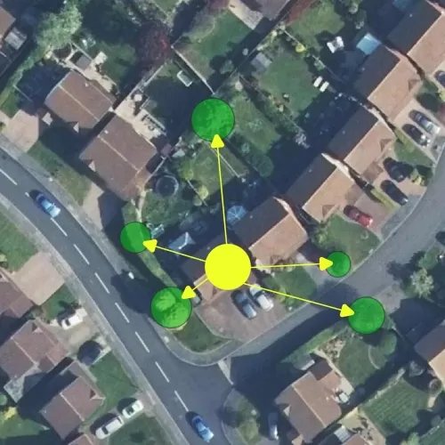
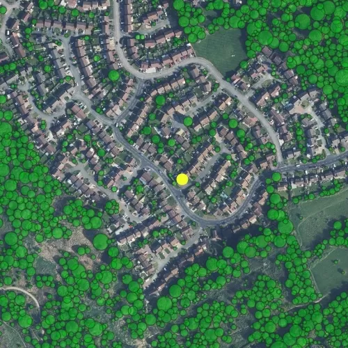
The first part of the rule states that every person should be able to see at least three large trees from their home. Multiple studies have shown that access to urban green spaces and visibility of nature improves mental wellbeing, physical health and has environmental benefits, including improved air quality and increased biodiversity. Although no specific research identifies that 3 trees should be visible, anecdotal evidence suggests being able to see urban nature from your home or workplace will have a positive impact on your day-to-day life.
Research conducted in the UK (2) analysed street tree density and its impact on mental wellbeing, with a specific focus on depression. The study discusses how depression is on the rise, particularly in high-risk groups such as those with lower socio-economic status and the unemployed. The study found that people living or working within 100m of a higher density of street trees had a lower risk of mental health issues. For individuals in deprived groups, the positive effects of street tree proximity were increased.
The 30-component
The 30-component states there should be a minimum of 30% canopy cover in each neighbourhood within a city. Research from around the world, including in the UK, has proven the benefits of tree canopy cover. A research project in Australia (3) demonstrated that a canopy cover of 30% or more in an urban area reduces the risk of cardiovascular disease, diabetes and hypertension. Greener neighbourhoods encourage people to spend more time outdoors and this, in turn, has a positive impact on physical health and mental health due to the increased social interaction this brings.
Trees for Cities (4) conducted a study showing that shade produced by trees can reduce urban temperatures by 2-8ºC. Trees act as natural flood defences, clean our air, and improve biodiversity. Analysis on a neighbourhood level generates statistics that can be turned into actionable intelligence across all socio-economic groups.
The 300-component
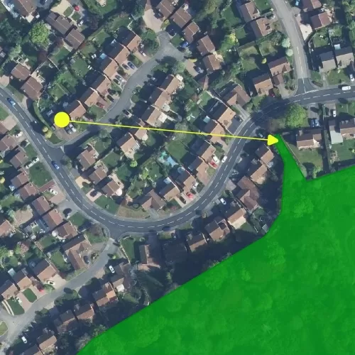
The final aspect of the rule suggests every person should live within 300 metres of an accessible green space. Not only does visibility of urban nature have benefits, but having access to a green space has significant impacts on mental well-being. In 2016, the World Health Organisation (WHO) released its Urban Green Space and Health report (5). The report recommends that people should be within 300m or a 5-minute walk of an accessible green space to ensure benefits to physical and mental well-being are seen.
The 300-component of the rule outlines that these green spaces should be no smaller than 1 hectare (ha) to encourage recreational use. In densely populated urban environments where space is a challenge, 0.5ha green space size is the recommended minimum size. The UK Government’s green infrastructure framework (6) sets out targets for urban greening which includes 0.5ha of green space within 200m of all homes, 2ha of green space within 300m and 10ha within 1km.
The role of geospatial data in urban planning
Geospatial data refers to information that is associated with a specific location on the Earth’s surface. It includes a wide range of data types, from satellite imagery and aerial photography to GPS coordinates and environmental sensor readings. In urban planning, geospatial data is invaluable for mapping, analysing, and understanding the spatial relationships between elements of the built and natural environments.
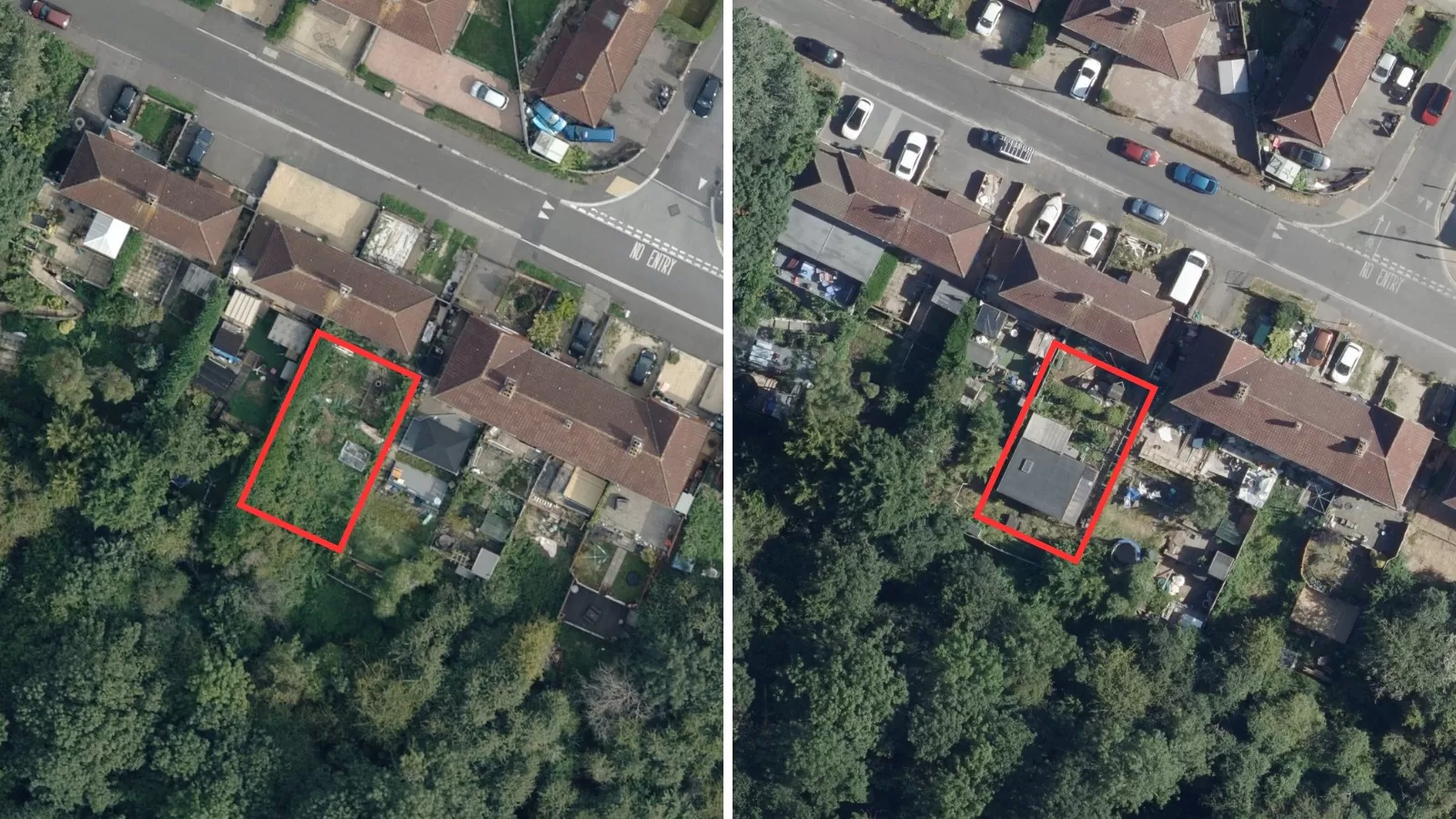
Bluesky’s NTM™ is one such geospatial dataset that provides detailed information about the location, height, and canopy extents of trees 3 metres and taller across Great Britain and the Republic of Ireland. The NTM™ is created using a combination of high-resolution aerial photography, digital height models, and colour-infrared data offering accurate and detailed information about urban forestry.
The effectiveness of the 3+30+300 rule lies in the ability to map and understand to what extent it is being achieved in an urban environment. Using geospatial datasets to analyse this in urban environments enables planners to assess existing tree cover, identify gaps in green space accessibility and create urban plans that successfully meet guidelines set out by 3+30+300. Advanced geospatial datasets like the NTM™ facilitate this analysis to be undertaken for any urban environment across Great Britain and the Republic of Ireland.
Mapping the 3+30+300 rule
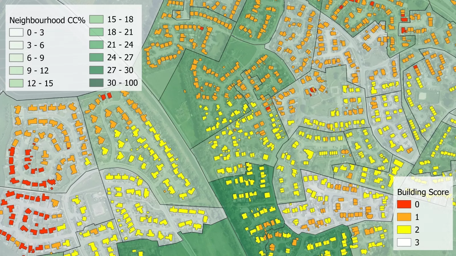
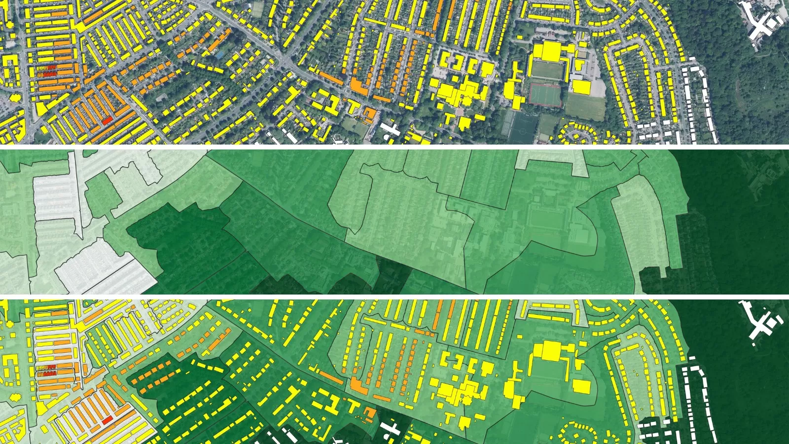
A new analysis service, designed as an ‘add-on’ to the NTM™, has been developed, analysing the 3+30+300 score of buildings and neighbourhoods across Great Britain. Understanding how buildings and neighbourhoods score on this rule enables prioritisation for tree planting to be incorporated into urban planning. This analysis service has been developed to assist urban planners in the public and private sectors at the forefront of urban greening and creating sustainable cities.
Bluesky’s analysis provides a digital map illustrating all 3 components of 3+30+300, as well as providing an overall score for each building. For the neighbourhood analysis, statistics on how many buildings meet each component are calculated. In addition to the digital map layer, a PDF report and guide are provided.
The results of this analysis can be used for urban planning of green infrastructure, green space and tree planting. It can be applied to aid community engagement on urban greening projects, demonstrating why a project is needed and the benefits it will have. Combining the data with other data layers, such as public health and urban heat islands, provides valuable insights into the correlation between trees and other factors.
This rule is becoming widely accepted and increasingly integrated into urban plans across Europe. Using a geospatial analysis tool can facilitate the benchmarking and monitoring of progress. Having a consistent way of measuring urban greening allows for comparisons to other cities. The NTM™ data is updated on a 2-year rolling programme so supports regular monitoring of tree planting and increases in canopy cover.
Limitations to the 3+30+300 rule
As cities become more densely populated, ensuring access to green spaces is increasingly challenging. To effectively implement this rule, working in a local context is important. Due to limited space in densely populated areas, achieving 30% canopy cover or 300m access to a 1ha+ green space may not be possible. For densely populated areas, an alternative green space size or accessibility distance could be chosen to better suit the area. Alternative green spaces could also be included, such as green roofs or indoor gardens.
Despite numerous advantages, there are some disadvantages to increasing green cover in an area. ‘Green gentrification’ is the process of increasing green space leading to a rise in house prices, with increased quality of life as places are seen as being more desirable to live. This can cause displacement of low-income households and those who need the benefits of green space the most. In turn this can cause environmental injustice as environmental hazards reduced by trees and green space disproportionally impact vulnerable people (7).
One study conducted in Sweden (8) suggests that a 2+20+200 rule would be more achievable due to the challenges that have arisen trying to meet the 3 and 30 components. The 3+30+300 rule should be used to guide urban greening rather than implemented as policy. Where necessary changes to each component could be met to better suit the urban context.
Conclusion
The 3+30+300 rule provides a clear and actionable framework for integrating nature into urban environments and promoting physical and mental well-being. However, achieving this goal requires detailed knowledge of existing urban green spaces and tree cover, as well as strategic planning for future development.
Bluesky’s new 3+30+300 analysis service utilises the NTM™ and offers a powerful geospatial option for urban planners to implement the 3+30+300 rule. By providing detailed, high-resolution data on tree location and canopy extent, the NTM™ can be used to calculate tree distribution in an urban area. Advanced analysis such as the 3+30+300 dataset enables planners to identify areas in need of green infrastructure, to plan tree planting and the creation of green spaces accordingly.
As cities around the world continue to grow, the integration of geospatial data into urban planning processes will be essential for creating sustainable cities. By using datasets like the NTM™ and 3+30+300 tool, urban planners can ensure urban greening is equitably distributed across a city providing multiple benefits to all people.
References
- Konijnendijk, 2021 – Paper linked here
- Marselle et al, 2020 – Paper linked here
- Astell-Burt, 2020 – Paper linked here
- Trees for Cities, 2024 – Paper linked here
- World Health Organisation, 2016 – Paper linked here
- Natural England, 2023 – GI Standards (naturalengland.org.uk)
- Barcelona Laboratory for Urban Environmental Injustice and Sustainability, 2024 – Website linked here
- Daland, 2023 – Paper linked here