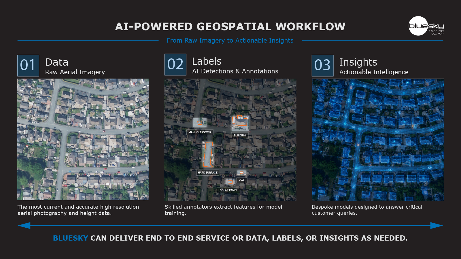
Bluesky International a Woolpert Company, the UK’s leading aerial survey company, is enabling SLR Consulting to push the boundaries of geospatial machine learning, with applications spanning renewable energy, Biodiversity Net Gain (BNG), and ecological monitoring. By applying Bluesky’s aerial photography, LiDAR, Digital Terrain Models (DTMs), Digital Surface Models (DSMs), and the National Tree Map™ within AI-driven workflows, SLR is significantly improving the speed, accuracy, and scalability of environmental analysis.
Through Bluesky’s web services GeoStream, SLR’s Geospatial Data and Solutions (GD&S) department has integrated high-resolution aerial photography and elevation data into machine learning pipelines that automate previously manual processes. This includes:
- Automated Habitat Classification: Using supervised and semi-supervised classification models trained on aerial photography and terrain data, SLR can predict and map habitat types across large, complex sites. This pre-mapping process replaces labour-intensive field-based digitisation, accelerating project delivery and improving consistency.
- Biodiversity Net Gain (BNG) Monitoring: Machine learning models process RGB imagery and canopy data from the National Tree Map™ to classify habitats against biodiversity frameworks. This ensures clients meet statutory BNG requirements while enabling repeatable, auditable outputs.
- 3D Windfarm Modelling: Combining DTMs, DSMs, and LiDAR with CAD/BIM, SLR develops data-rich 3D models for windfarm developments. These models, enhanced with machine learning-derived habitat layers, provide realistic simulations for consultation and planning, with high levels of accuracy in terrain, vegetation, and built features.
- Scalable Ecology Analysis: Object-Based Image Analysis (OBIA) and Convolutional Neural Networks (CNNs) are applied to Bluesky’s imagery to detect and classify vegetation and land cover at scale. This supports ecological teams in delivering rapid site assessments for large developments.
Jacob Scoble, Associate GIS Analyst at SLR Consulting, said: “The GeoStream service has been critical for us as it gives access to data for the whole of Great Britain. We have 60 users across the organisation, primarily in the GD&S team, but the outputs from the data are used widely across the business. Via GeoStream we access aerial photography, the National Tree Map™, Digital Terrain Models, and Digital Surface Models. Our CAD Team have been able to use these datasets to create a recently-developed windfarm 3D model.
“Having the imagery has really been a critical part of the machine learning we have applied for some key projects. The data, coupled with the capabilities of artificial intelligence and machine learning, significantly increases what we can do with the imagery, so the geospatial datasets are a big enabler for us.”
By integrating high-quality geospatial datasets into AI and ML workflows, SLR has been able to train models that generalise across diverse landscapes, reducing site-specific overheads and unlocking consistent outputs across projects. The ability to automate classification tasks means SLR can reallocate ecological expertise to validation and higher-level analysis, rather than manual digitisation.
Ralph Coleman, Chief Commercial Officer at Bluesky, added:
“SLR Consulting are demonstrating the role of geospatial data in powering artificial intelligence. When high-resolution aerial imagery and LiDAR are paired with advanced classification algorithms, the outputs go beyond visualisation, they become predictive, scalable, and directly actionable. This is where the industry is heading, and we’re excited to see how SLR is leading the way.”