With ambitious plans to tackle climate change, Ireland has already seen a dramatic increase in energy generated from renewable resources yet there is still a growing demand that is not being met by carbon neutral production. Aerial mapping company Bluesky believes a resistance to renewable energy infrastructure is part of the problem and explores how geographic data is helping to plan and communicate solar and wind farms across the country. Robert Loughran, International Sales Manager for Bluesky, shares his thoughts.
The Republic of Ireland has ambitious targets to tackle climate change with published plans to reduce overall greenhouse gas emissions by 51% by 2030 and achieve net zero by 2050 at the latest.
Fundamental to these plans is a rapid transition to a net zero-carbon energy system with current targets seeing an increase in the proportion of electricity generated from renewable energy sources from 30% to up to 80% by 2030. The Irish economy has recovered well from the financial crisis in 2008, but this has not come without a cost as recent years have seen emissions start to grow again, demonstrating a failure to break the link between emissions and prosperity.
However, Ireland’s geography makes it uniquely placed to face these challenges and achieve these targets. The Republic of Ireland has a land area of 70,272 square kilometres, bounded to the west and north-west by the Atlantic Ocean, in the south by the Celtic Sea and in the east by the Irish Sea. Ireland normally gets between 1,100 and 1,600 hours of sunshine each year peaking in May and June and has some of the highest average wind speeds in Europe.
Although recent years have seen a dramatic increase in energy generated from renewable resources such as solar, wind, tidal and geothermal there is more to be achieved.
Ireland’s first commercial wind farm was commissioned at Bellacorrick, Co Mayo in 1992. There are now just over 300 windfarms currently in operation, with a total installed capacity of 4332.5 MegaWatts (MW), with the largest having an installed capacity of 169 MW. In 2019 32% of all energy generated was from wind and this avoided 3.9 million tonnes of CO2 emissions.
In contrast 2022 saw the opening of Ireland’s first large scale solar farm. Located near Ashford in Co Wicklow, Millvale solar farm incorporates 33,600 solar modules covering 25 hectares of land. With a generation capacity of 8 megawatts of electricity, enough to power approximately 3,600 homes, it is estimated this will prevent 4,800 tonnes of greenhouse emissions a year.
Whilst undoubtedly good news some may be surprised that this first was only recently achieved, that is until you look closer into the facts and figures and the history of renewable energy, specifically solar, in Ireland.
As recently as early 2019 there were no operational solar farms in the Republic of Ireland. This is despite the fact that more than 80 developments were granted permission between 2015 and 2018. As a result, solar power accounted for just 0.03% of Ireland’s overall energy supply for electricity consumption in 2017, although this was a three-fold increase on solar PV generation capacity over the previous 12 months according to the Department of Communications, Climate Action and Environment.
Despite the government promoting green energy generation in a number of ways; through tax incentives and supports, such as those for micro generation, and through schemes such as the Renewable Energy Feed-in Tariff (REFIT) scheme and Renewable Electricity Support Scheme (RESS), the nation’s Environmental Protection Agency has warned that Ireland will fail to meet climate action targets unless it speeds up its emission-reduction policies, particularly for the agriculture and transport sectors. Other threats to targets include increased coal use and growing energy demand, including from data centres. Meanwhile, the rise in working from home and the increasing cost of fossil fuels highlights the need for houses to become more energy efficient, the report published by the EPA said.
So, what can be done to increase the rate at which renewable energy projects, specifically solar, are approved, developed and come on-grid? Aerial mapping company Bluesky International, the only commercial organisation to have captured and maintained complete coverage of high-resolution imagery and terrain data for the whole of the Republic of Ireland, thinks a better understanding of the physical impact projects have, or are perceived to have, on the local environment may be key to overcoming opposition and speeding up bureaucracy.
Bluesky has already supplied geographic data including aerial photography, terrain, tree mapping and topographic mapping, to support both the initial planning and final design of a significant number of renewable energy schemes across Ireland. With off-the-shelf data as well as bespoke capture projects, this data has been used by more than twenty five (renewables and supporting engineers) companies working on hundreds of solar pv farms, 50 plus wind farms and more than 10 grid connections. The data is also supplied to both local and central government organisations, who obviously have a fundamental role in the planning of these projects.
Landscape consultancy firm Macro Works, uses Digital Terrain (the bare surface of the earth excluding vegetation and buildings) and Digital Surface Models (the earth’s surface including buildings and vegetation) to better understand how solar farms could be seen from the surrounding area and the impact reflected light might have on existing properties and infrastructure. Working on behalf of solar energy developers across the Republic, Macro Works uses the models to produce several outputs, including Zone of Theoretical Visibility (ZTV) maps and Glint and Glare assessment reports. These, together with a Landscape Mitigation Plan, have already helped secure permission for over 100 solar farms, including Ireland’s largest, at the time, permitted development to the north-west of Midleton, County Cork.
“Traditional ZTV mapping is based on bare-ground terrain data, however, the DSM data allows screening by existing vegetation and buildings to be accounted for and also allows us to incorporate proposed mitigation and examine its effectiveness,” commented Luis Dominguez, Senior GIS Analyst at Macro Works. “This form of analysis is extremely useful for placing a new structure into almost any setting but is particularly effective for solar developments where we use the process to inform both our Landscape and Visual Impact Assessments and Glint and Glare analysis.”
“Before DSM data was readily available, we captured and processed our own models using a survey-grade drone,” he continued, “however, this was weather dependent, time consuming and expensive. Now that that data has been captured and is being maintained we can access high quality DSM data for the whole of the Republic of Ireland.”
Another company taking advantage of geospatial data is Irish flood consultancy Hydro Environmental. Using LiDAR (Light Detection and Ranging), captured using aircraft mounted lasers, and photogrammetrically derived Digital Surface Models (DSM), Hydro Environmental is saving time, and money, on resource intensive site visits as it carries out essential analysis to determine suitable locations for wind farm sites. Drainage patterns are a key part of the assessment stage, in addition to ensuring that existing areas of environmental importance, like peatlands which absorb carbon, are not disturbed.
“To analyse the drainage patterns for proposed sites we need a clear picture of where existing streams are located and run to,” commented Michael Gill, Director at Hydro Environmental. “The LiDAR provides a comprehensive and accurate depiction with a deeper view of the land. Importantly, it shows us the areas that would not be suitable for development.”
Hydro Environmental is also using DSM data to analyse areas under tree canopies to assess drainage. “Using the DSMs we can digitise forestry drainage which is then exported to engineering drawings and integrated with drainage plans for wind farm site applications. Without the data we would have to physically survey the under-tree canopy areas and this would prove near impossible.”
These are just some of the innovative ways up to date, accurate and readily available geographic data is being used to inform the planning, design and delivery of renewable energy projects in Ireland. The fight against climate change is an important one that needs properly informed decisions. Geospatial data already does, and must continue to, play a key role in supporting public and private initiatives ensuring plans and recommendations can be made confidently knowing accurate analysis has driven them.
This same data can also be used to communicate decisions in an easy to digest way. Site plans, graphics and 3D visualisations are fundamental to public consultations and can be a critical tool in addressing the concerns of community groups and environmental organisations. This will hopefully ensure that we continue our journey towards the ultimate destination of a net zero energy system.
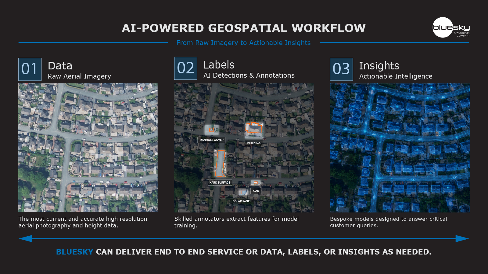
In an ambitious step Bluesky, in partnership with Ecopia AI, recently announced its intention to create the first ever 3D land cover map of Ireland. Generated from Bluesky’s 12.5 and 25 cm resolution aerial photography, Ecopia’s Artificial Intelligence based mapping systems will create and maintain a map that includes high-precision vector layers for features including everything from buildings to roads, pavements and bridges to sports facilities and retail outlets, and parks and forests. It is hoped that this comprehensive, accurate and up-to-date resource will enable informed geospatial decision making for a host of applications including renewable energy planning. An evaluation sample is currently available and full coverage of Ireland is expected in Q4 of 2023.