January 2026
-
SLR Consulting Harnesses Bluesky International’s Geospatial Data to Advance Machine Learning for Sustainability and Renewable Energy Projects
Bluesky International a Woolpert Company, the UK’s leading aerial survey company, is enabling SLR Consulting to push the boundaries of geospatial machine learning, with applications spanning renewable energy, Biodiversity Net…
Read More
May 2025
-
Scottish Council Leading the Way with Cross-Function Application of Green Space Analysis
3+30+300 research rule applied to support health, housing, infrastructure and green space strategies Analysis visuals support resident engagement activities 3+30+300 analysis created using GB’s only comprehensive tree mapping dataset Aberdeenshire…
Read More
April 2025
-
UK Utility Company Launches New Dashboard to Manage Tree Safety Across Expansive Region
Wessex Water applies National Tree Map™ data to map trees on landholding Supports a focus on managing high priority sites like those next to railways Aims to ensure public and…
Read More
January 2025
-
Bluesky International Aerial Imagery and Data Helps Crack Carbon Capture Equation
Nottingham City Council and Nottingham University using Bluesky data to enable calculations National Tree Map™ imagery and data aids with carbon storage calculation Carbon map now influencing planning policy and…
Read More
May 2024
-
New Mapping Technology Shows Carbon Stored In Britain’s Much-Loved Hedgerows
New geospatial mapping technology is enabling the carbon storage benefit of Great Britain and Ireland's hedgerows to be calculated from the skies. The nation’s hedgerows have been in the spotlight over recent…
Read More
March 2024
-
Bluesky National Tree Map Helps Protect Galway City’s Biodiversity
Galway City Council is applying Bluesky International’s unique National Tree Map (NTM) data to assist the development of strategic planning policy designed to protect and support wildlife trying to survive…
Read More
May 2022
-
Bluesky’s National Tree Map Helps Improve Biodiversity in London
A project targeting biodiversity gain and climate change resilience in Bloomsbury, London is turning to data from Bluesky International’s National Tree Map (NTM) to ensure proposals are built on evidence-based…
Read More
March 2022
-
Bluesky 3D Models Help Macro Works Plan Milestone Solar Farm in Ireland
3D maps derived from the latest aerial photography are being used to secure planning permission for solar farms across the Republic of Ireland. Created by Bluesky International, the Digital Terrain…
Read More -
Tree Carbon Capture Figures are More Accurate Thanks to Bluesky’s National Tree Map
Tree carbon capture figures in West and North Yorkshire are now being recorded more accurately as experts have turned to data from the National Tree Map. This unique dataset, created…
Read More
February 2022
-
Waterford City and County Council Use Bluesky National Tree Map Data to Support Carbon Neutral Plans
Data from Bluesky International’s National Tree Map is being used by Waterford City and County Council to help benchmark current tree cover across the city and to look at suitable…
Read More -
Bluesky Aerial Photography Helps Derby Homes Boost Solar Energy Output and Reduce Carbon Emissions
Aerial mapping company Bluesky is helping Derby Homes roll out integrated solar photovoltaic (PV) systems across its housing stock. A project to identify suitable roof coverings assessed more than 8,000…
Read More
December 2021
-
Bluesky Aerial Photography used to Map Green Roofs
Bluesky International Ltd, the UK’s leading aerial survey and mapping company, has supplied its high-resolution photography to support a new artificial intelligence platform created by technology start-up Gentian. The platform…
Read More
November 2021
-
Bluesky National Tree Map Data Included in First Online Natural Capital Calculator
The first online natural capital mapping tool in the UK – NatCap Map – is using data from Bluesky’s National Tree Map™. Developed by Natural Capital Research, the tool allows…
Read More
October 2021
-
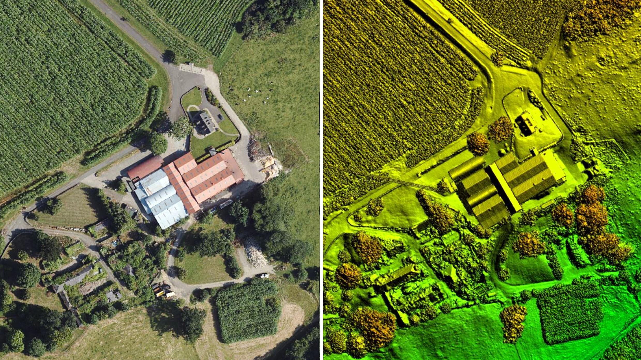
Bluesky LiDAR Benchmarks Carbon Neutral Farming in Northern Ireland
A European Innovation Partnership project to accelerate the move towards net carbon zero farming is using specially commissioned LiDAR data to create a baseline for future measurements. Working with ARCZero…
Read More
September 2021
-
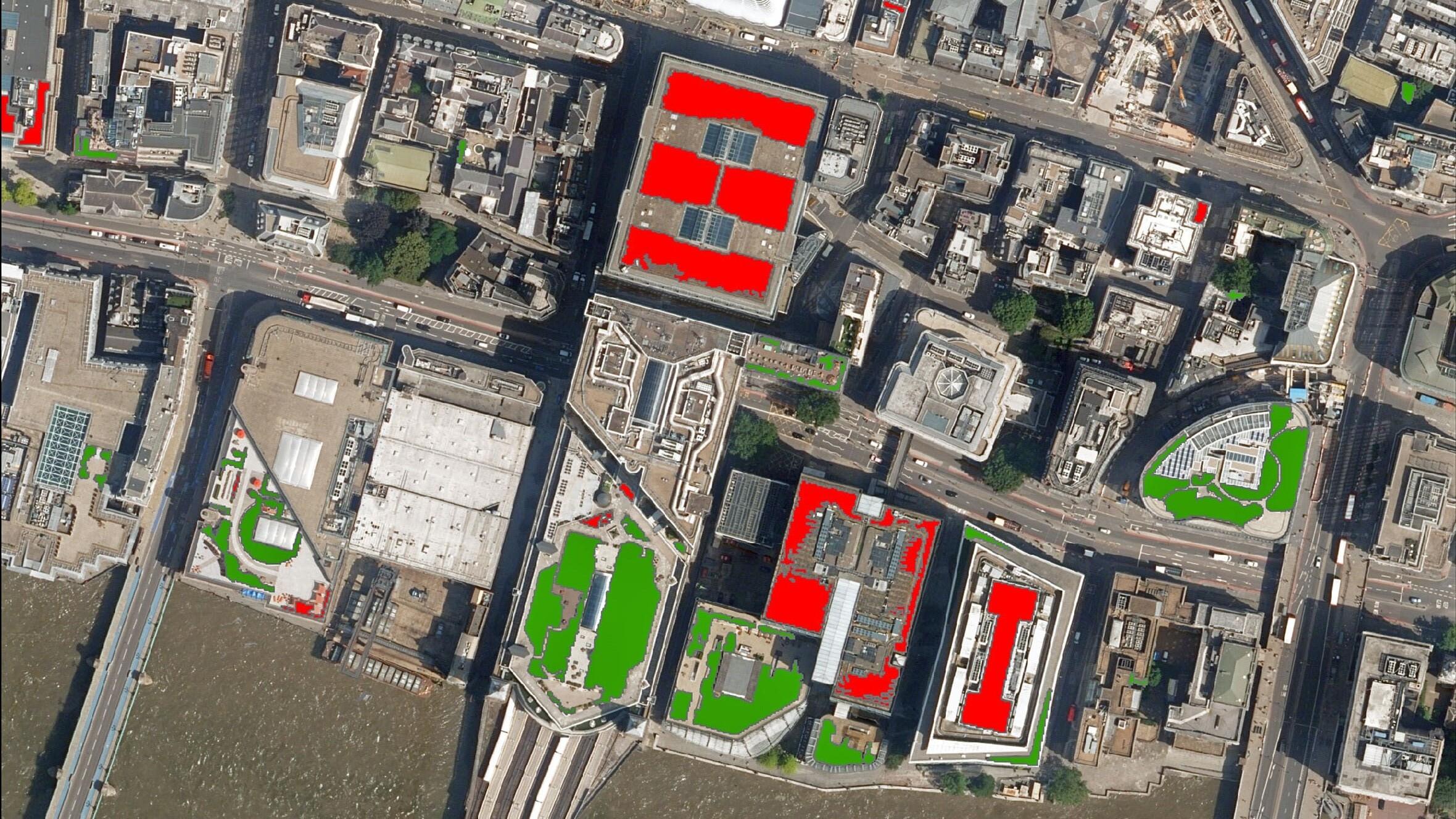
MWA Arboriculture uses Bluesky National Tree Map to Inform Tree Condition Surveys
Arboricultural consultancy MWA Arboriculture is using data from the National Tree Map, the only map that details the location and attributes of more than 300 million trees, to inform tree…
Read More -
Bluesky National Tree Map™ at the Root of Birmingham’s Urban Forest Master Plan
An extract from a map that details the location and attributes of more than 300 million trees is being used to create the UK’s first Urban Forest Master Plan (UFMP).…
Read More -
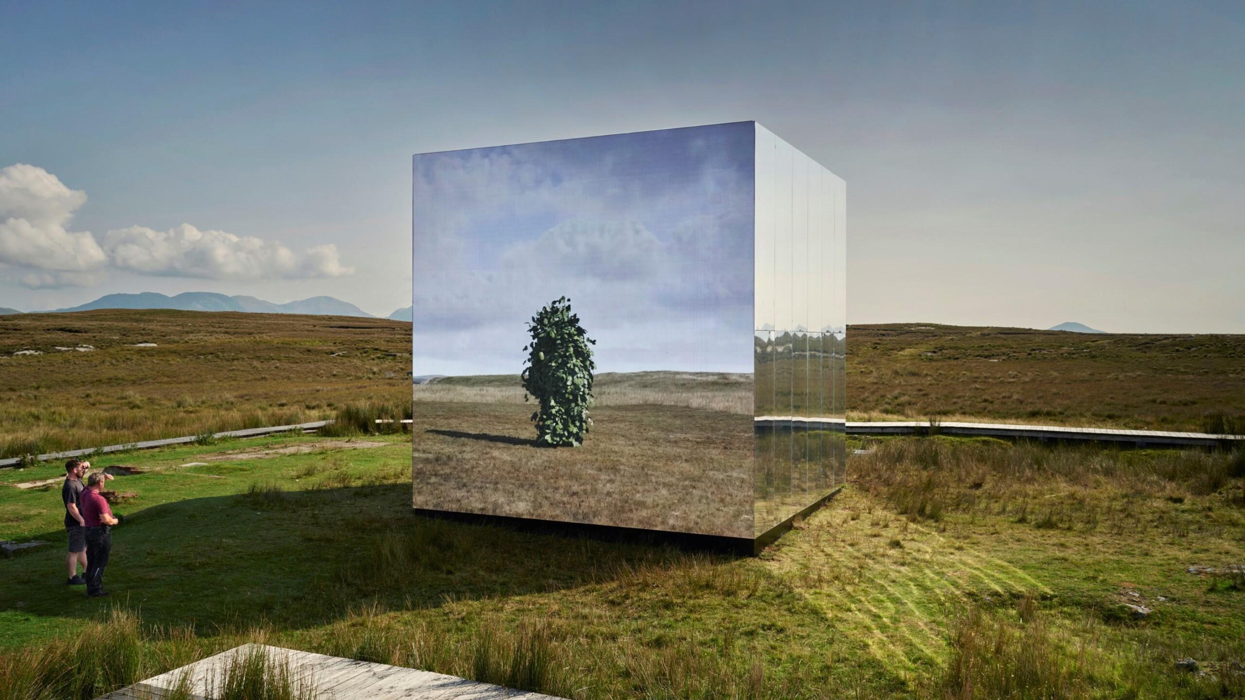
Bluesky Aerial Photomaps Feature in International Arts Festival
Mirror Pavilion, Leaf Work, (Derrigimlagh) 2020 by John Gerrard photo by Ros Kavanagh Aerial photography and 3D height models from Bluesky are informing a new art installation in Ireland. Part…
Read More
August 2021
-
Bluesky Cyclomedia Partnership Combines Aerial and Mobile Mapped Data for Virtual City Models
Aerial mapping company Bluesky International is working with the Dutch mobile mapping specialist Cyclomedia to bring together imagery and height data, captured from the air and at street level, to…
Read More
July 2021
-
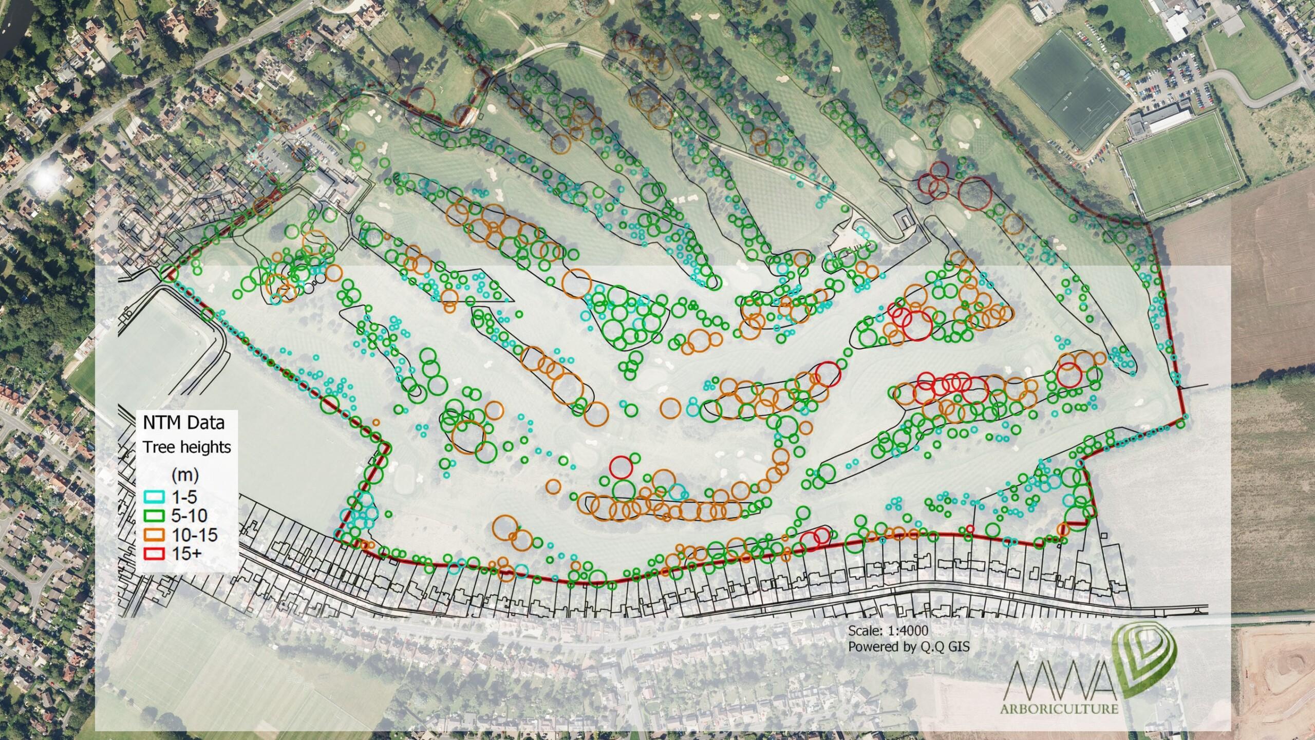
Bluesky National Tree Map Shows Changing Face of Sevenoaks District’s Historic Tree Cover
A new map detailing the location, height and canopy for trees over 3 metres in height is helping Sevenoaks District Council manage its iconic ancient trees and natural woodland. Derived…
Read More
June 2021
-
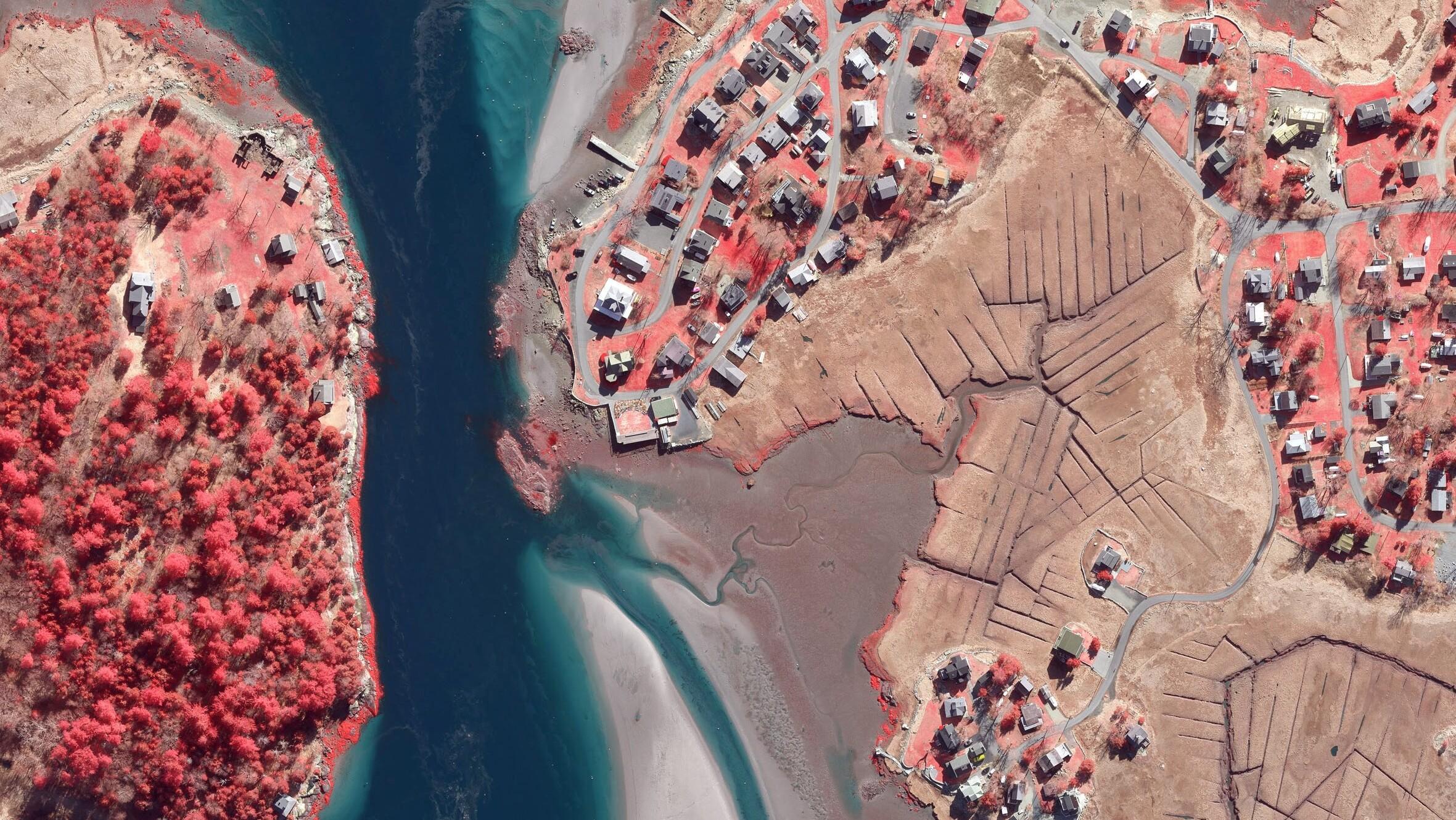
Boston University Uses Bluesky Aerial Photomaps to Research Climate Change
Researchers at Boston University are using high resolution aerial photography to investigate how important coastal ecosystems are responding to climate change. The study focused on an area of salt marsh…
Read More
May 2021
-
Bluesky Aerial Maps Light the Way for Contaminated Site Investigation and Clean Up
Aerial mapping company Bluesky has completed a topographic survey of the old Anchor Color and Gum Works site in Dighton, Massachusetts. Working with Lighthouse Land Surveying, LLC and under strict…
Read More
April 2021
-
Wiltshire Council uses Bluesky National Tree Map to Manage Public Tree Stock
Wiltshire Council is using data from a map which details the location and attributes of more than 300 million trees to improve the management of its trees in parks and…
Read More
January 2021
-
Bluesky National Tree Map Reveals Carbon Capture Potential of Natural Woodlands
A map detailing the location and attributes of more than 300 million trees is being used to research the role of natural woodland in meeting climate change targets. With UK…
Read More -
Bluesky LiDAR Used to Visualise Peatland Restoration on Royal Estate
Data collected from survey aircraft equipped with advanced laser scanners is being used by the James Hutton Institute to monitor the natural restoration of land at the Queen’s Balmoral Estate…
Read More