April 2025
-
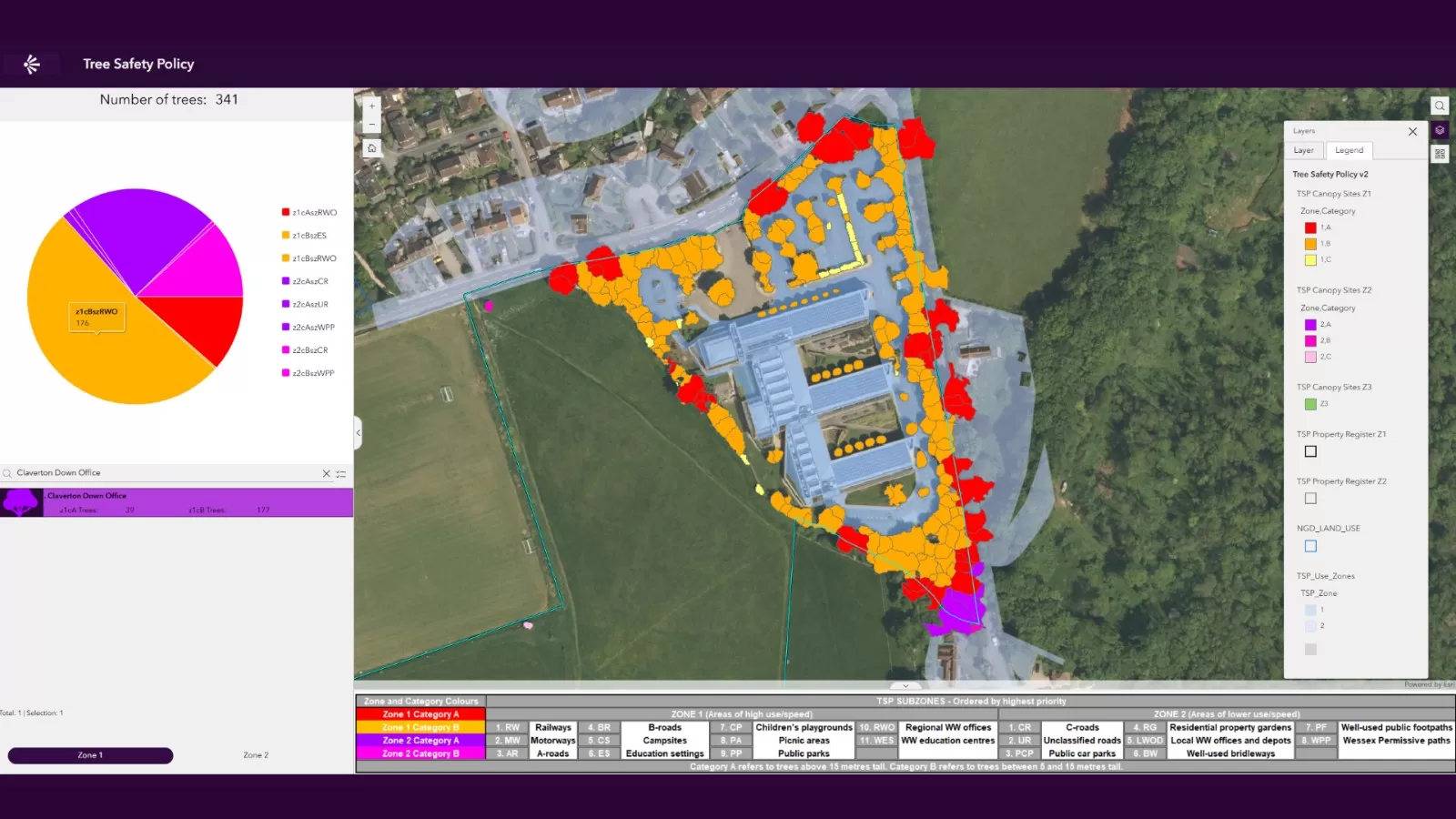
UK Utility Company Launches New Dashboard to Manage Tree Safety Across Expansive Region
Wessex Water applies National Tree Map™ data to map trees on landholding Supports a focus on managing high priority sites like those next to railways Aims to ensure public and…
Read More -
University of Leicester Partners with Bluesky International to Revolutionise Tree Mapping Technology
The University of Leicester has joined forces with one of the UK’s leading providers of aerial survey and geospatial data, Bluesky International Ltd, to transform the way we understand trees.…
Read More
January 2025
-
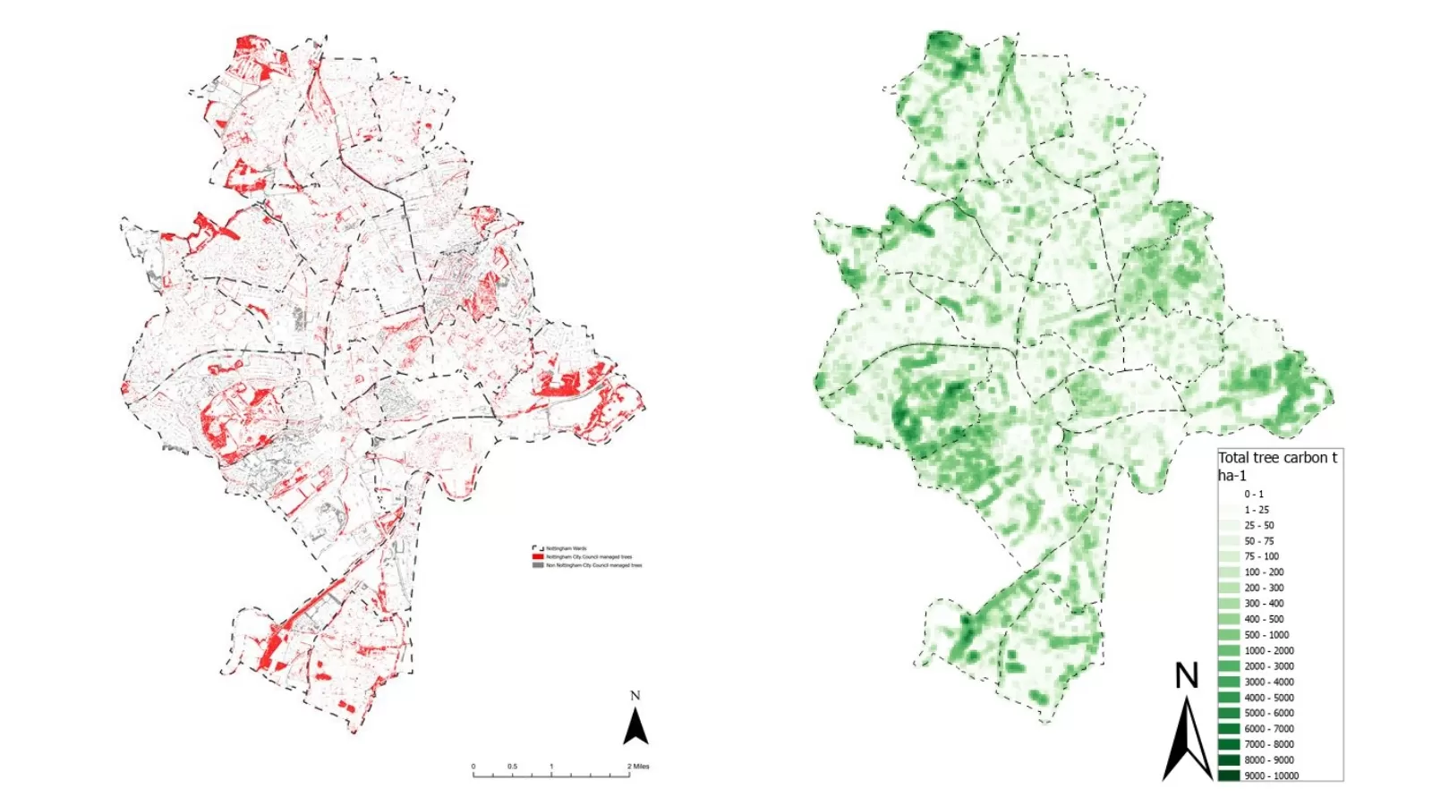
Bluesky International Aerial Imagery and Data Helps Crack Carbon Capture Equation
Nottingham City Council and Nottingham University using Bluesky data to enable calculations National Tree Map™ imagery and data aids with carbon storage calculation Carbon map now influencing planning policy and…
Read More -
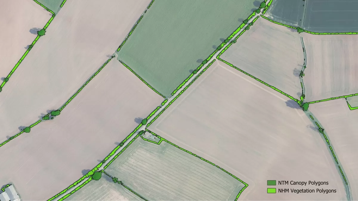
National Hedgerow Map Fills ‘Gap’ in Available Data For Specialist Environmental Consultancy
NHM™ supports important Biodiversity Net Gain calculations A detailed hedgerow map that facilitates rapid carbon capture calculations NHM™ complements Bluesky’s established National Tree Map™ to offer comprehensive vegetation analysis Just…
Read More
November 2024
-
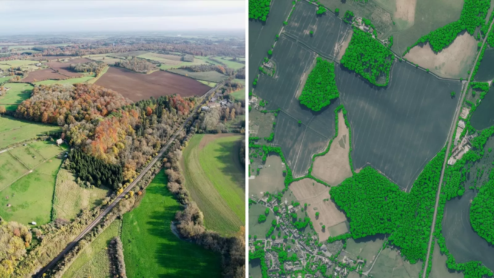
Bluesky National Tree Map Data Supports Vital Conservation Work at Blenheim Palace
Aerial mapping data will analyse how trees at UNESCO World Heritage Site have changed over time Data will inform planned projects to increase woodland Follows work to create the largest…
Read More -
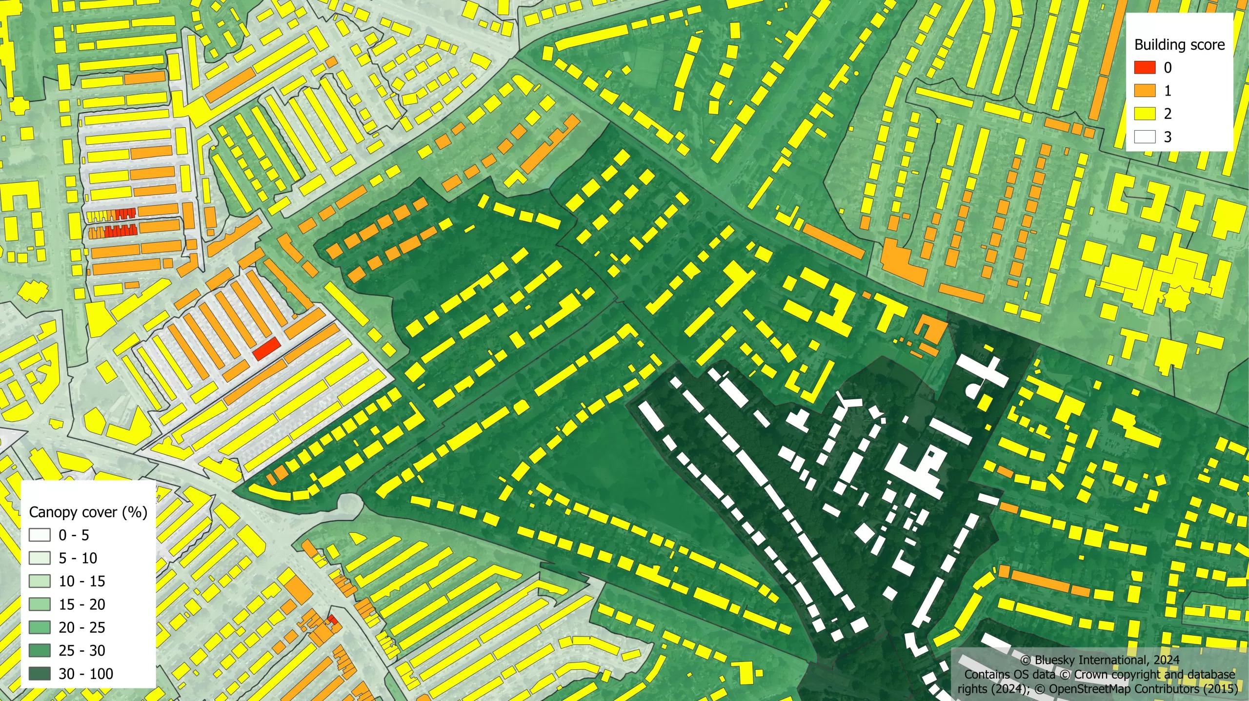
Urban Tree and Green Space Calculation Tool Gives Clarity on Priority City Areas in Urgent Need of Greening Initiatives
Designed to offer insight into areas that do not meet requirements detailing proximity to trees and green space Developed applying the 3+30+300 rule to the unique National Tree Map™ Snapshot…
Read More -
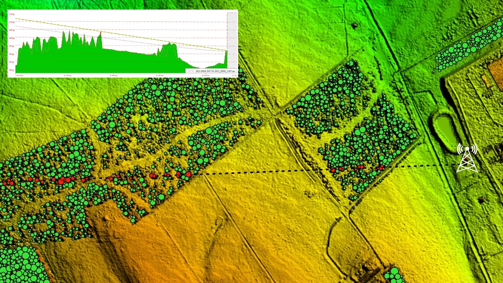
National Tree Map Helps Deliver Clear Signals Between Critical Data Masts Up To 90km Apart
Aerial mapping technology can help to identify tree growth obstructing wireless communications links Power utilities utilise wireless communications links to control the electricity grid Keeping these links unobstructed is key…
Read More
May 2024
-
New Mapping Technology Shows Carbon Stored In Britain’s Much-Loved Hedgerows
New geospatial mapping technology is enabling the carbon storage benefit of Great Britain and Ireland’s hedgerows to be calculated from the skies. The nation’s hedgerows have been in the spotlight over recent…
Read More
March 2024
-
Bluesky National Tree Map Helps Protect Galway City’s Biodiversity
Galway City Council is applying Bluesky International’s unique National Tree Map (NTM) data to assist the development of strategic planning policy designed to protect and support wildlife trying to survive…
Read More
June 2023
-
Bluesky Makes a Record Breaking Start to the 2023 Mapping Flying Season
Aerial mapping company Bluesky International has made a record-breaking start to its 2023 flying season having captured more than 96 per cent of its UK flying target in the first…
Read More -
LexisNexis Improves Insurer Risk Assessment Portfolio with National Tree Map
A new suite of geospatial products has been launched by LexisNexis Risk Solutions in a bid to address weather-related challenges faced by the UK and Ireland insurance market. Bluesky International…
Read More -
Birmingham Council Creates Interactive Mapping Portal using Bluesky Tree Data
Birmingham City Council has launched a first of its kind mapping portal to address the issue of tree equity across the city. With National Tree Map data, created by aerial…
Read More
April 2023
-
Bluesky Launches New Data-as-a-Service Offering
A new geospatial data subscription service has been launched by aerial survey and mapping company Bluesky designed to ensure customers can access data they need, when they need it, without…
Read More -
Bluesky Partners with Berlin-based UP42 to Supply Aerial Imagery and Geospatial Data
Bluesky International announces a new partnership with Berlin-based UP42, a leading geospatial developer platform and marketplace. The recently signed agreement will see Bluesky supply its accurate, high resolution aerial imagery…
Read More
March 2023
-
Cardiff Council Addresses Flood Risk Using Bluesky National Tree Map
Cardiff Council is using an aerial map of trees to help it prioritise essential works in order to reduce the risk of surface water flooding. Created by Bluesky International, the…
Read More -
How Green is the London Marathon? Aerial Mapping Company Bluesky Reveals All
Aerial mapping company Bluesky International has completed a study into tree canopy cover at differing points along the route of the upcoming London Marathon. Using its unique database of more…
Read More
February 2023
-
Bluesky Tree Map Enhances Online Urban Forest Mapping Platform
Greentalk, a London based ecotech start-up, is offering a map of trees from Bluesky International within its online urban forest engagement platform. Incorporating Bluesky’s National Tree Map data, Greentalk will…
Read More
January 2023
-
Bluesky National Tree Map Helps Dudley Council Keep Black Country Green
A unique map database from Bluesky International is helping Dudley Metropolitan Borough Council inform research and development projects, engage with stakeholders and ensure the historic capital of the Black Country…
Read More
December 2022
-
Bluesky National Tree Map Helps Bradford District Council Manage Tree Disease
A local authority has turned to data from aerial survey and mapping company, Bluesky International, to manage tree health and felling across a 98-hectare estate and areas of an adjoining…
Read More -
Tree Map Data Key Tool To Protect Highways From Falling Trees
A unique tree mapping tool is being used by Leicestershire County Council as part of its programme to help keep its highways safe throughout the county. The local authority is…
Read More
November 2022
-
Research by Bluesky International Reveals Link Between Trees and Happiness
Research by aerial mapping company Bluesky International has shown a direct correlation between happiness and the ‘greenest’ London Boroughs. By comparing its unique database of more than 3 million trees…
Read More
July 2022
-
Bluesky’s Tree Map Helps Green Infrastructure Planning for Swansea Housing
Bluesky International’s geospatial data is providing environmental insights and informing future green space plans in a bid to enhance resident well-being, improve air quality, maximise biodiversity and improve surface water…
Read More
May 2022
-
Bluesky’s National Tree Map Helps Improve Biodiversity in London
A project targeting biodiversity gain and climate change resilience in Bloomsbury, London is turning to data from Bluesky International’s National Tree Map (NTM) to ensure proposals are built on evidence-based…
Read More
March 2022
-
Tree Carbon Capture Figures are More Accurate Thanks to Bluesky’s National Tree Map
Tree carbon capture figures in West and North Yorkshire are now being recorded more accurately as experts have turned to data from the National Tree Map. This unique dataset, created…
Read More
February 2022
-
Waterford City and County Council Use Bluesky National Tree Map Data to Support Carbon Neutral Plans
Data from Bluesky International’s National Tree Map is being used by Waterford City and County Council to help benchmark current tree cover across the city and to look at suitable…
Read More
November 2021
-
Bluesky National Tree Map Data Included in First Online Natural Capital Calculator
The first online natural capital mapping tool in the UK – NatCap Map – is using data from Bluesky’s National Tree Map™. Developed by Natural Capital Research, the tool allows…
Read More
September 2021
-
MWA Arboriculture uses Bluesky National Tree Map to Inform Tree Condition Surveys
Arboricultural consultancy MWA Arboriculture is using data from the National Tree Map, the only map that details the location and attributes of more than 300 million trees, to inform tree…
Read More -
Bluesky National Tree Map™ at the Root of Birmingham’s Urban Forest Master Plan
An extract from a map that details the location and attributes of more than 300 million trees is being used to create the UK’s first Urban Forest Master Plan (UFMP).…
Read More
August 2021
-
Bluesky appoints Europa Technologies as reseller for National Tree Map
Bluesky International has appointed Europa Technologies as an authorised reseller for the National Tree Map (NTM). The NTM is the foremost environmental database of its kind. With coverage across Great…
Read More -
WhenFresh partners with Bluesky to give insurers vital access to National Tree Map data
WhenFresh has teamed up with tree mapping specialists Bluesky to make its National Tree Map™ (NTM™) data available to insurers and other Big Data users, via the UK’s property ‘Data…
Read More
July 2021
-
Bluesky National Tree Map Shows Changing Face of Sevenoaks District’s Historic Tree Cover
A new map detailing the location, height and canopy for trees over 3 metres in height is helping Sevenoaks District Council manage its iconic ancient trees and natural woodland. Derived…
Read More
April 2021
-
Wiltshire Council uses Bluesky National Tree Map to Manage Public Tree Stock
Wiltshire Council is using data from a map which details the location and attributes of more than 300 million trees to improve the management of its trees in parks and…
Read More
January 2021
-
Bluesky National Tree Map Reveals Carbon Capture Potential of Natural Woodlands
A map detailing the location and attributes of more than 300 million trees is being used to research the role of natural woodland in meeting climate change targets. With UK…
Read More