November 2025
-
Why Change Detection Analysis leveraging Aerial Photography is Essential for Planning Compliance
Built environments are changing rapidly which means planning departments face the dual challenge of enabling growth while ensuring developments remain within agreed parameters. One of the most powerful tools available…
Read More
January 2025
-
Bluesky International Aerial Imagery and Data Helps Crack Carbon Capture Equation
Nottingham City Council and Nottingham University using Bluesky data to enable calculations National Tree Map™ imagery and data aids with carbon storage calculation Carbon map now influencing planning policy and…
Read More
December 2024
-
High Resolution Aerial Imagery from Bluesky Applied in Revolutionary New AI Tool Launched to Support UK Housing Developers
A new AI platform to support UK’s SME housing developers High resolution aerial data imagery supports developer decisions on site viability Accurate data supports risk analysis and financial planning A…
Read More
November 2024
-
Bluesky National Tree Map Data Supports Vital Conservation Work at Blenheim Palace
Aerial mapping data will analyse how trees at UNESCO World Heritage Site have changed over time Data will inform planned projects to increase woodland Follows work to create the largest…
Read More
October 2024
-
Bluesky International’s High-Resolution Aerial Photos Used to Map UK’s Solar Panels
Tool designed by Geospatial Insight shows UK’s solar set up Data will be used by local authorities, businesses and clean energy sector It’s hoped information will help fuel transition to…
Read More
September 2024
-
Historic Imagery Archives From Britain’s Leading Aerial Imagery Providers Made Available To All Public Sector Organisations
Imagery archives dating back to 1999 offer valuable window to the past Public sector organisations can access imagery at no cost to them Awarded as part of the recently announced…
Read More
July 2024
-
Bluesky Named Sole Supplier of Aerial Photography to UK Government
£15m+ deal places Leicestershire-based Bluesky at forefront of UK aerial data provision Geospatial Commission awards specialist contract to sole supplier for the first time Deal places Leicestershire firm at the…
Read More
May 2024
-
Bluesky Moves to Two-Year GB Aerial Capture Programme
240,000 sq kms of GB updated every 2 years 12.5cm GB wide coverage 5cm resolution imagery of all urban areas DSM, DTM, NTM, NHM also updated on 2 year programme…
Read More
March 2024
-
Bluesky International Donates £1,500 to Help Maintain Story of Ashby-de-la-Zouch
Bluesky International has stepped in to help preserve historical local pictures from its neighbourhood’s past. The aerial mapping company offered to make a donation to Ashby-de-la-Zouch Museum after it emerged…
Read More
February 2024
-
Bluesky Aerial Photos at Heart of New Met Police Mapping Tool
High resolution aerial photography from Bluesky International is informing day-to-day decision making, long-term planning and reporting at the Metropolitan Police Service. Supplied as part of a multi-million-pound Government mapping contract,…
Read More
December 2023
-
Bluesky Partners with Sensat Providing Data for New Visualisation Tool
A new data visualisation tool has been developed and launched designed to support civil infrastructure teams expediate access to data during the planning phase enabling more informed decision making and…
Read More -
Peak District Pioneers High Resolution AI Landscape Mapping using Bluesky Aerial Images
The Peak District National Park Authority, in partnership with Cranfield University and The Alan Turing Institute, is pioneering the use of Artificial Intelligence (AI) to automate the production of highly…
Read More
November 2023
-
Anglian Water Alliance Streams Bluesky Aerial Mapping for Web App
An alliance that is delivering £1.2 billion of capital investment schemes for Anglian Water is streaming aerial maps to improve decision making, with the aim of reducing site visits. The…
Read More
September 2023
-
MWH Treatment uses 3D Building Models from Bluesky to Drive Innovation in Water Sector
MWH Treatment is using highly detailed, geographically accurate 3D models to create visualisations, animations and interactive applications that are improving standards for safe and sustainable solutions within the water sector.…
Read More -
Bluesky 3D Imagery Brings Global Warming Sea Level Rises to Life
Immersive story telling company Sairo has used high resolution aerial photography and 3D mapping from UK aerial survey and mapping company Bluesky International to illustrate the impact of global warming…
Read More
August 2023
-
Bluesky Aerial Data Helps CGL Pinpoint Natural Hazards at Development Sites
A geotechnical and consultancy agency is using geospatial data to work smarter, saving significant time and money, both for themselves and their clients. Card Geotechnics Ltd (CGL) is applying aerial…
Read More
July 2023
-
Bluesky’s Airborne Sensors Help Developers Protect Wildlife Habitats
Multi-spectral imagery from Bluesky International is helping developers contribute to government targets to protect and conserve wildlife habitats in the UK. Using the latest Artificial Intelligence (AI) technology, in combination…
Read More
April 2023
-
Bluesky and Ecopia Partner to Create First 3D Map of Ireland
Bluesky International and Ecopia AI (Ecopia) have announced a partnership to develop the first ever 3D land cover map of Ireland. Generated using Bluesky’s 12.5 and 25 cm resolution aerial…
Read More -
Bluesky Launches New Data-as-a-Service Offering
A new geospatial data subscription service has been launched by aerial survey and mapping company Bluesky designed to ensure customers can access data they need, when they need it, without…
Read More -
Bluesky Partners with Berlin-based UP42 to Supply Aerial Imagery and Geospatial Data
Bluesky International announces a new partnership with Berlin-based UP42, a leading geospatial developer platform and marketplace. The recently signed agreement will see Bluesky supply its accurate, high resolution aerial imagery…
Read More
March 2023
-
Bluesky Partners with SkyFi to Widen Access to its Aerial Imagery Catalogue
Bluesky International announces a new partnership with SkyFi, an American company, based in Texas, that aims to democratise access to earth observation assets by providing access of multi-perspective imagery to…
Read More
October 2022
-
Bluesky International announced as supplier for new Ordnance Survey framework
Bluesky International, a leading UK aerial survey and mapping company, has fought off stiff competition to be named as one the selected organisations to sit on a new framework created…
Read More
June 2022
-
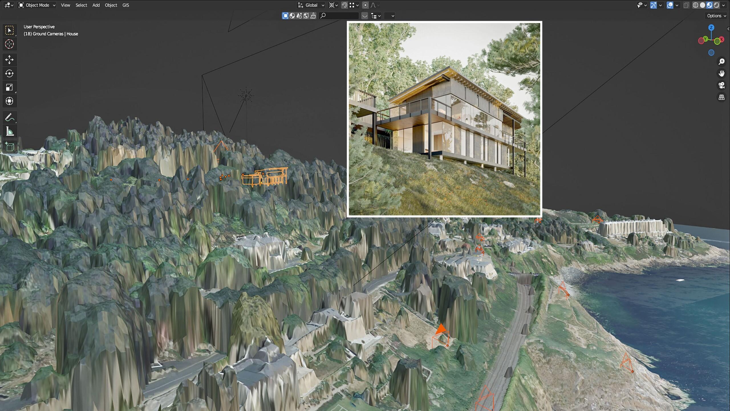
Bluesky LiDAR and Aerial Photography Bring Builds to Life for Dublin Design Studio
A Dublin based architectural consultancy is using data from aerial survey and mapping company Bluesky International to ensure the planning process is conducted as efficiently and smoothly as possible for…
Read More
February 2022
-
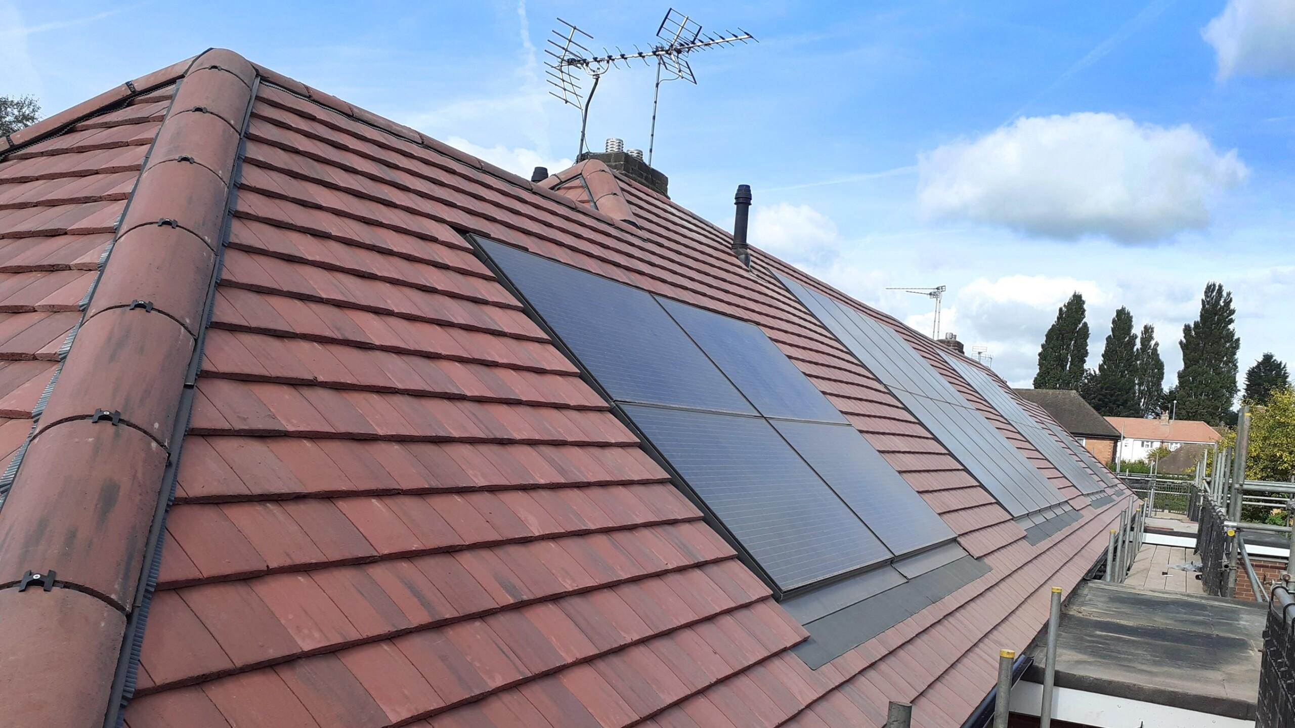
Bluesky Aerial Photography Helps Derby Homes Boost Solar Energy Output and Reduce Carbon Emissions
Aerial mapping company Bluesky is helping Derby Homes roll out integrated solar photovoltaic (PV) systems across its housing stock. A project to identify suitable roof coverings assessed more than 8,000…
Read More
December 2021
-
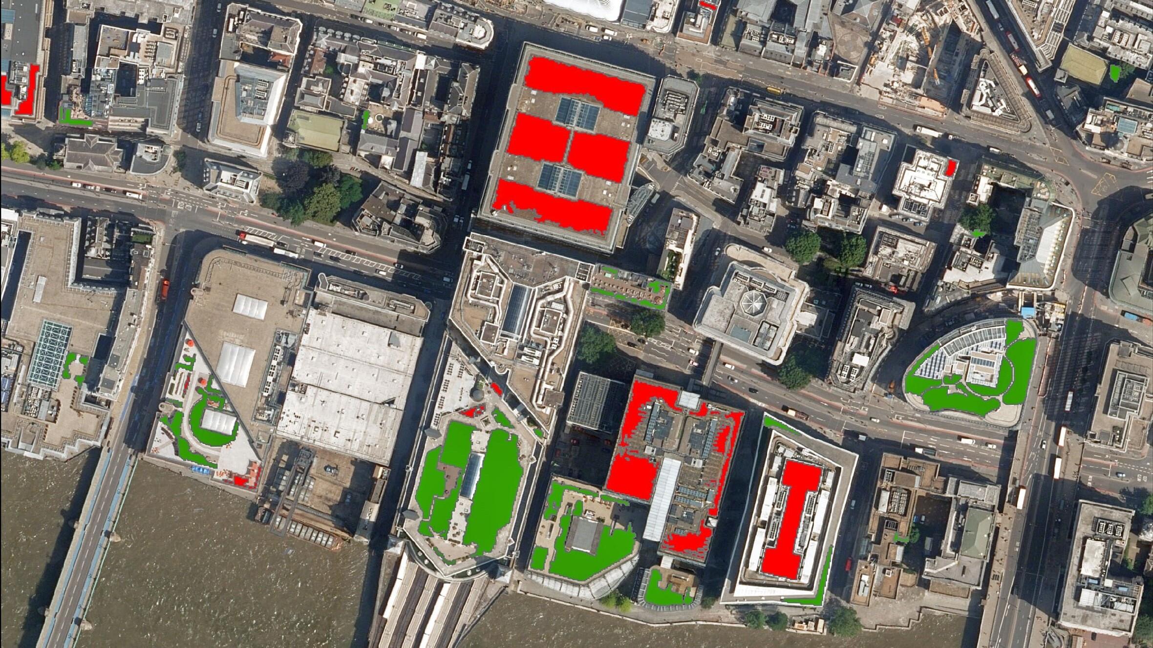
Bluesky Aerial Photography used to Map Green Roofs
Bluesky International Ltd, the UK’s leading aerial survey and mapping company, has supplied its high-resolution photography to support a new artificial intelligence platform created by technology start-up Gentian. The platform…
Read More
September 2021
-
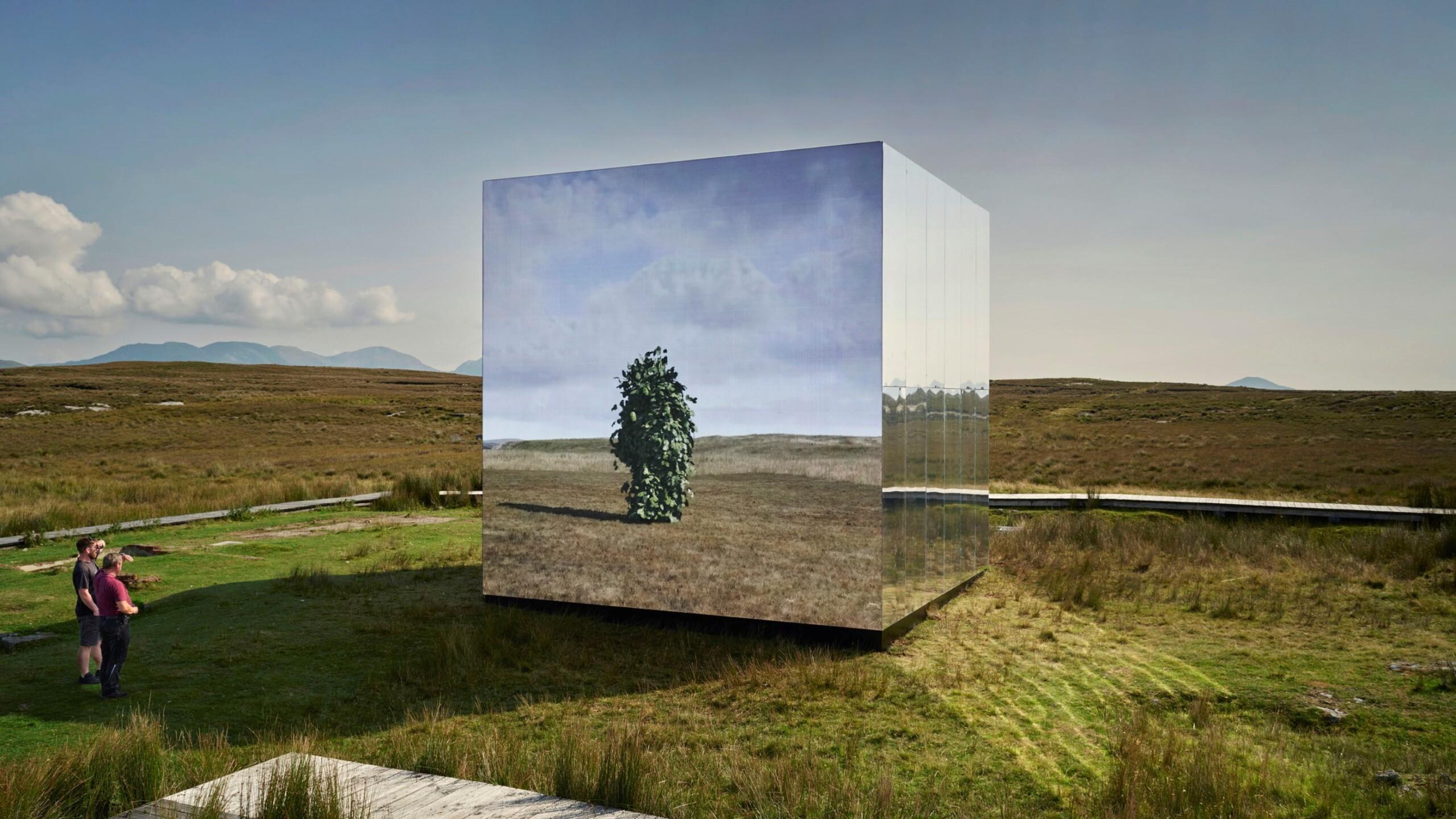
Bluesky Aerial Photomaps Feature in International Arts Festival
Mirror Pavilion, Leaf Work, (Derrigimlagh) 2020 by John Gerrard photo by Ros Kavanagh Aerial photography and 3D height models from Bluesky are informing a new art installation in Ireland. Part…
Read More
August 2021
-
Bluesky Cyclomedia Partnership Combines Aerial and Mobile Mapped Data for Virtual City Models
Aerial mapping company Bluesky International is working with the Dutch mobile mapping specialist Cyclomedia to bring together imagery and height data, captured from the air and at street level, to…
Read More
June 2021
-
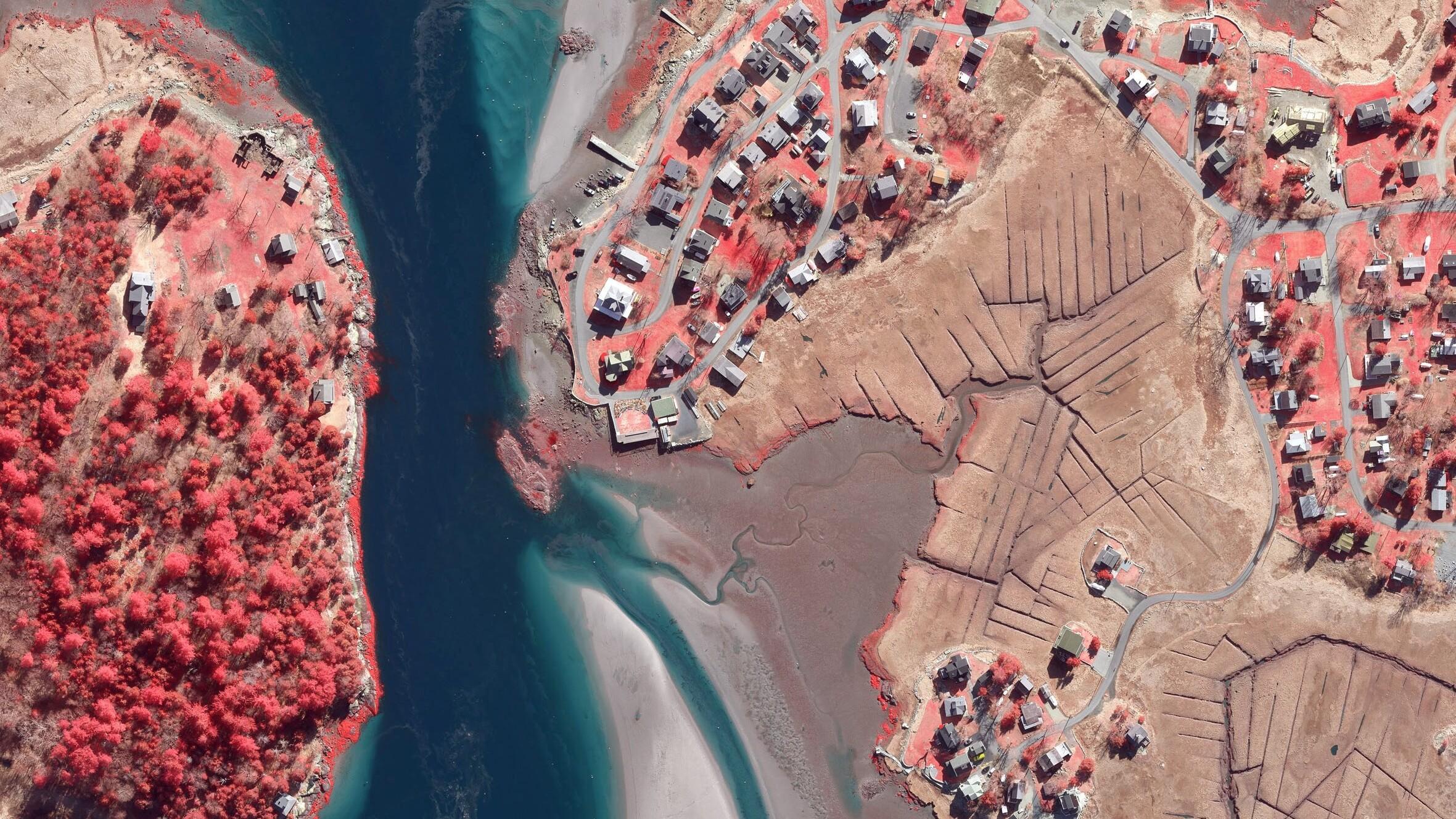
Boston University Uses Bluesky Aerial Photomaps to Research Climate Change
Researchers at Boston University are using high resolution aerial photography to investigate how important coastal ecosystems are responding to climate change. The study focused on an area of salt marsh…
Read More
May 2021
-
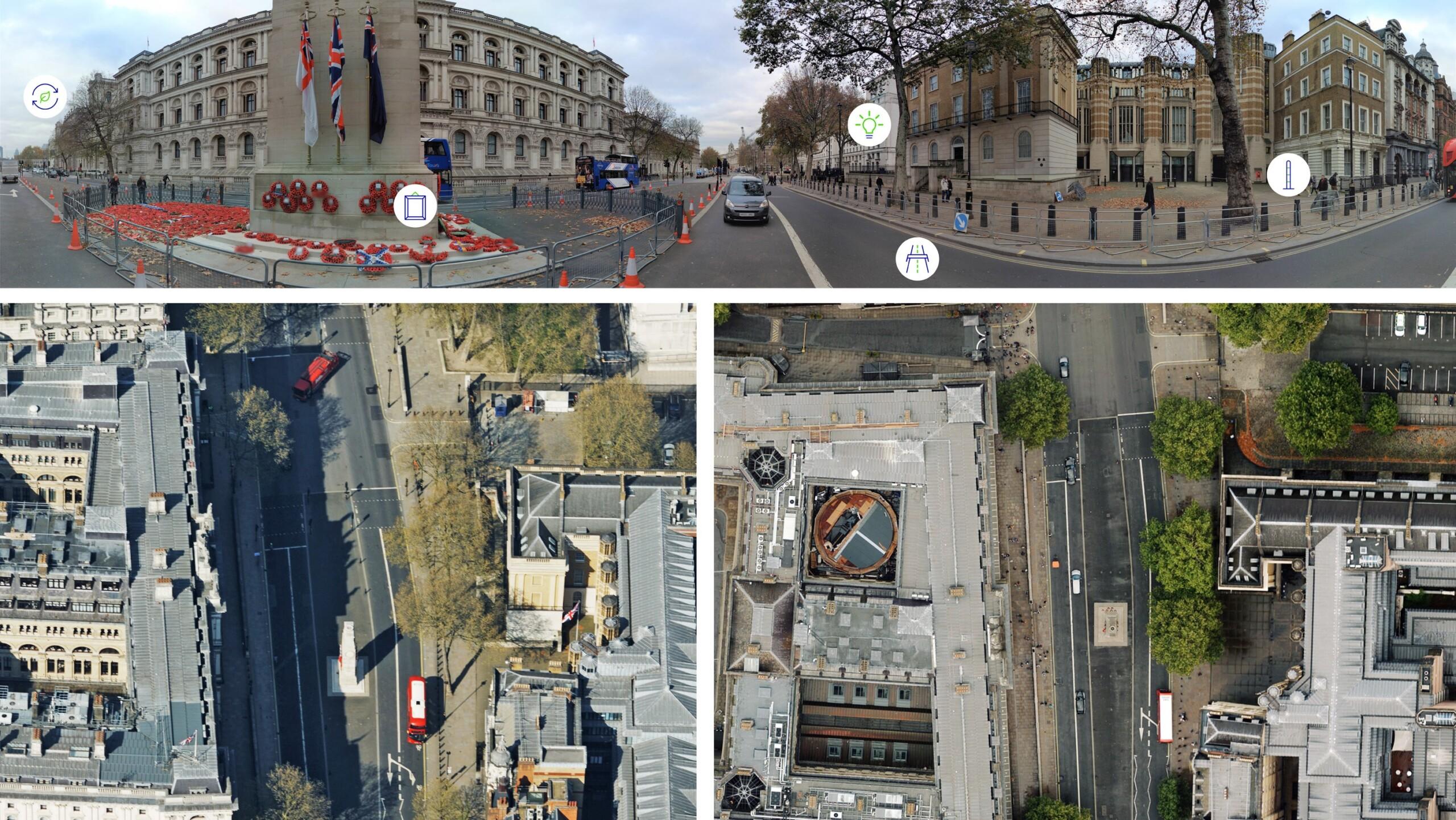
Bluesky 5cm Aerial Photography Reveals Hidden Parts of London
Southwark Council is using the highest resolution photography from Bluesky to inform frontline service provision and decision making across its planning, transport, housing and environment operations. The 5cm data offers…
Read More -
Bluesky Aerial Maps Light the Way for Contaminated Site Investigation and Clean Up
Aerial mapping company Bluesky has completed a topographic survey of the old Anchor Color and Gum Works site in Dighton, Massachusetts. Working with Lighthouse Land Surveying, LLC and under strict…
Read More
January 2021
-
Bluesky National Tree Map Reveals Carbon Capture Potential of Natural Woodlands
A map detailing the location and attributes of more than 300 million trees is being used to research the role of natural woodland in meeting climate change targets. With UK…
Read More